Highway Functional Classification Definitions
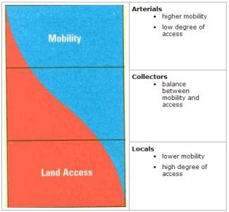
The Highway Functional Classification System defines the role a roadway plays in the overall road network. Each roadway is classified in two ways. First by whether it is ‘urban’ or ‘rural’ as defined by Rhode Island’s Transportation Urban Rural Boundary area (and should not be confused with Land Use 2025’s Future Land Use Map’s Urban Services Boundary), and second by its function within the network. In general the two basic functions of a roadway are access to property and travel mobility. Mobility refers to the actual ability of the road to move traffic, while accessibility refers to the ease of entering or exiting a roadway to or from adjacent priorities. Arterials have high mobility but low land access and are typically used for longer trips. Whereas, local roads have low mobility (travel at slower speeds) but provide the highest level of land access. These are used for shorter trips around town. Collectors are in the middle and often act as the transitional roads from arterials to local roads.
To avoid the problem of failure, a classification of roadways, based on function and, the preferred design of each class of road is established so that as opportunities arise, roads can be improved appropriately. Roadways are classified according to the following classifications:
Interstates are the highest classification of Arterials and were designed and constructed with mobility and long-distance travel in mind. Since its inception in the 1950’s, the Interstate System has provided a network of limited access, divided highways offering high levels of mobility while linking the major urban areas of the United States. Roadways in this functional classification category are officially designated as Interstates by U.S. Secretary of Transportation, and all routes that compromise the Dwight D. Eisenhower National System of Interstates and Defense Highways belong to the Interstate functional classification category and are considered Principal Arterials. Rhode Island examples include I-95, I-295, and I-195.
Roadways in this functional classification category look very similar to Interstates. While there can be regional differences in the use of the terms ‘freeway’ and ‘expressway,’ for the purpose of functional classification the roads in this classification have directional travel lanes usually separated by some type of physical barrier, and their access and egress points are limited to on- and off-ramp locations or a very limited number of at-grade intersections. Like Interstates, these roadways are designed and constructed to maximize their mobility function, and abutting land uses are not directly served by them.
These roadways serve major centers of metropolitan areas, provide a high degree of mobility and can also provide mobility through rural areas. Unlike their access-controlled counterparts, abutting land uses can be served directly. Forms of access for Other Principal Arterial roadways include driveways to specific parcels and at-grade intersections with other roadways. For the most part, roadways that fall into the top three functional classification categories (Interstate, Other Freeways & Expressways and Other Principal Arterials) provide similar service in both urban and rural areas. The primary difference is that there are usually multiple Arterial routes serving a particular urban area, radiating out from the urban center to serve the surrounding region. In contrast, an expanse of a rural area of equal size would be served by a single Arterial.
Collectors serve a critical role in the roadway network by gathering traffic from Local Roads and funneling them to the Arterial network. Within the context of functional classification, Collectors are broken down into two categories: Major Collectors and Minor Collectors. Until recently, this division was considered only in the rural environment. Currently, all Collectors, regardless of whether they are within a rural area or an urban area, may be sub-stratified into major and minor categories. The determination of whether a given Collector is a Major or a Minor Collector is frequently one of the biggest challenges in functionally classifying a roadway network.
In the rural environment, Collectors generally serve primarily intra-county travel (rather than statewide) and constitute those routes on which (independent of traffic volume) predominant travel distances are shorter than on Arterial routes. Consequently, more moderate speeds may be posted.
The distinctions between Major Collectors and Minor Collectors are often subtle. Generally, Major Collector routes are longer in length; have lower connecting driveway densities; have higher speed limits; are spaced at greater intervals; have higher annual average traffic volumes; and may have more travel lanes than their Minor Collector counterparts. Careful consideration should be given to these factors when assigning a Major or Minor Collector designation. In rural areas, AADT and spacing may be the most significant designation factors. Since Major Collectors offer more mobility and Minor Collectors offer more access, it is beneficial to reexamine these two fundamental concepts of functional classification. Overall, the total mileage of Major Collectors is typically lower than the total mileage of Minor Collectors, while the total Collector mileage is typically one-third of the Local roadway network.
Locally classified roads account for the largest percentage of all roadways in terms of mileage. They are not intended for use in long distance travel, except at the origin or destination end of the trip, due to their provision of direct access to abutting land. Bus routes generally do not run on Local Roads. They are often designed to discourage through traffic. As public roads, they should be accessible for public use throughout the year. Local Roads are often classified by default. In other words, once all Arterial and Collector roadways have been identified, all remaining roadways are classified as Local Roads.
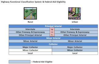
The functional classification is also used to determine federal funding priority and eligibility for Federal-Aid according to the table below.
Additional information on highway functional classification is available in the Federal Highway Administration’s Highway Functional Classification Concepts, Criteria, and Procedures, 2013 Edition.